

")
We have spent the week baking under a June-like sun, with temperatures to match. However, mid-April in WABBLES usually means chances for showers and storms to sweep through and drop those temperatures, and this weekend appears to be no exception.
Just Plain Hot: Friday and Friday Night
The reason for the warm spell as of late continues to be high pressure anchored across portions of the southeast and just off the coast. A little early for a Bermuda high, but it’s got that vibe to it nonetheless.

That’s kept the pattern rather summerlike around here, with a “ring-of-fire” type setup in place. While we bake under the influence of this ridge, storm systems rolling in from the Pacific have brought multiple waves of strong to severe storms to the nation’s midsection for the past week or so. Bake we shall continue to do today.

Strong southerly flow throughout the week will continue as we head through the afternoon hours, in addition to plenty of sunshine. That should allow temperatures to warm quickly into the afternoon, with highs topping out in the upper 80s close to 90º out there. Record high in Bowling Green for Friday is 90º (set in 1955), so we’ll be on RecordWatch yet again.

After a near record setting afternoon, a record setting overnight is not out of the question. With clouds coming and going in the southwest flow, that will keep temperatures from falling too much, with lows only in the upper 60s. By the way, the record warm low is 67º set back in, well, 2024. So, either way, it’s looking mild, muggy, and setting up for an active day on Saturday.
A Springtime Weekend: Saturday and Sunday
Yet again a tale of two weekend days around the region, from warm and windy to cool and clearing…so a typical mid-spring front on the way.

The frontal boundary heading our way Saturday is the one responsible for a whole boatload of severe weather expected throughout the nation’s midsection into the day on Friday. While the strengthening low will be pulling away into Canada, we’ve still got the cold front to get through, which might have just enough ingredients for some strong to severe thunderstorms.
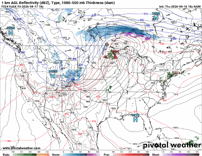
Some flies in the ointment here include the potential for showers in the morning that could help sap some of the instability for the afternoon as the front comes through, as well as timing remaining an issue. If storms come through in the afternoon and evening, the severe threat would be higher than if they came through later in the night. Nonetheless, we’ll keep an eye on a line of showers and storms that will try to push into the region.
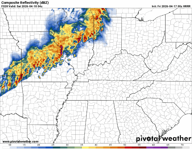
Being that these storms are in a line, it looks like pockets of damaging straight-line winds will be the main threats as these storms pass through. And as they do, let’s spare a thought for our meteorologist friends up in the River City this weekend and the gray hair this forecast during Thunder Over Louisville will be contributing to.

Breezy conditions continue after storms pass through, except we’re switching winds from the south to the north and west, quickly ushering in cooler temperatures as shower chances continue to wane overnight. Lows will fall back into the middle 40s, a bit closer to where we’re supposed to be this time of year!

We’ll trade the storm chances for sunshine into the day on Sunday as our cold front sweeps the moisture out of the air. Unfortunately, the tradeoff is that the front will also sweep the warm temperatures out of the region as well.

The sunshine will be brilliant, but the highs will be on the order of 20º+ cooler. After starting out slowly warming through the 50s in the morning, afternoon highs are back into the middle 60s. So, not bad. In fact, slightly below normal. But that’s going to feel dramatically different from what we were dealing with just 24 hours prior!

The cool weather continues overnight as dry air and clear skies allow lows to fall back into the lower 40s…with some upper 30s not out of the question in our usual sheltered locations.
Cool Start to the Week
High pressure from the north continues to dominate the weather headlines as we start the work week throughout the region keeping things sunny and mild. Perfect spring weather, really.

Sunshine continues into the afternoon with temperatures making it back in the vicinity of 70º. I would encourage you to approach your supervisors to perhaps move work out of doors on Monday afternoon. Clearing skies and calming winds overnight should allow lows to settle back near normal, back into the middle to perhaps upper 40s. More of the same, but warmer on Tuesday!

Sunshine continues, but winds start to shift around to the south as we head into the afternoon hours. That will allow temperatures to warm nicely back above average for daytime highs, with afternoon temps peaking yet again in the upper 70s to near 80º.
Clouds start to increase again as we head into the nighttime hours as moisture starts to move back into the region. That also means warmer air returns, with lows back into the lower to middle 50s.
That warmer and more moist atmosphere will bring us accelerated chances for showers and storms as it appears the pattern turns more active and unsettled
That’s it for me for now! You can always keep up with the latest on all of our social media platforms. Have a tremendous day and a great weekend!