Good Monday morning, friends in and around WABBLES! It’s a lovely day outside, which are a little bit hard to come by these days due to the active pattern that’s been keeping us rainy recently. Today’s start-of-the-week forecast is nothing short of a perfect summer experience, so if you have some outdoor activities you’ve been putting off for a bit, there is no better time to get out there and enjoy the sunshine! How long will these wonderful conditions last? We’ll go through the forecast together in today’s weather blog!
Today’s Forecast
Sunshine will abound starting bright and early this morning, with today’s sunrise expected by 5:32. A lack of significant cloud cover will warm us up quickly, and also make sunblock necessary for any folks planning to spend most of their Monday outside. High temperatures are expected to reach the mid-to-high 80s, which is perfectly average for this time of year! After sunset most of us will dip down into the low 60s, cooling us off comfortably before another day of high temperatures tomorrow.
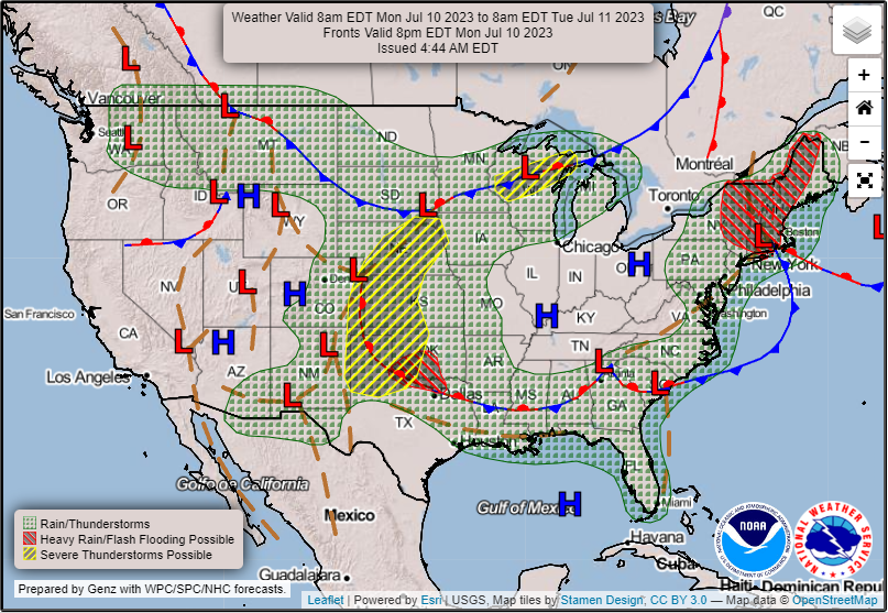
As depicted in the above image, a pretty large area of high pressure is warding off all the foul weather to our west and will be making its way out of the WABBLES area over the course of the week. But for today, dry weather and clear skies will abound!
What About Tomorrow?
Tuesday will be much the same story as today, aside from the chance to see some patchy fog early in the morning. WABBLES will be warmer, with our high temps hitting the high-80s to the low-90s, and we’ll have a slight southeast wind that strengthens over the course of the day. Starting early on Wednesday, the high pressure area that will have been warding off our chance for storms will begin eroding in earnest, bringing back the possibility of showers on Wednesday afternoon.
In addition, an area of cooler upper-atmosphere air has begun pushing its way down from the north over the last several days, which will provide some small relief in moisture influx to the region. Higher precipitation amounts will likely stay off to our west for a little while longer, until both the high pressure area and lower temperatures have assimilated back into typical summer warmth.
Is That All?
Yep, it pretty much is! WABBLES, expect to revel in some sunny skies and summerlike conditions through the middle of the week before our active pattern catches back up to us. Keep that sunblock handy and pay attention to the blog here, because no matter what we’ll be here every day to walk through the forecast. Until next time, take care of yourselves out there!