

")
Good Wednesday Morning y’all! I hope everyone around WABBLES has enjoyed the snow these past few days, despite the wicked cold. Even with all the snow we got the other day, we have yet another snow chance on the horizon.

Time for the Snow to Melt?
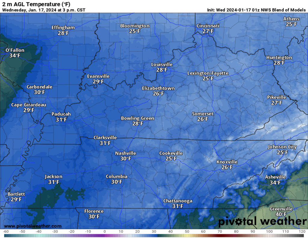
The high notes for today’s forecast is abundant sunshine and temperatures warming up to around freezing. The NWS blend of models has WABBLES topping out in the upper 20s, which I think is a good number.
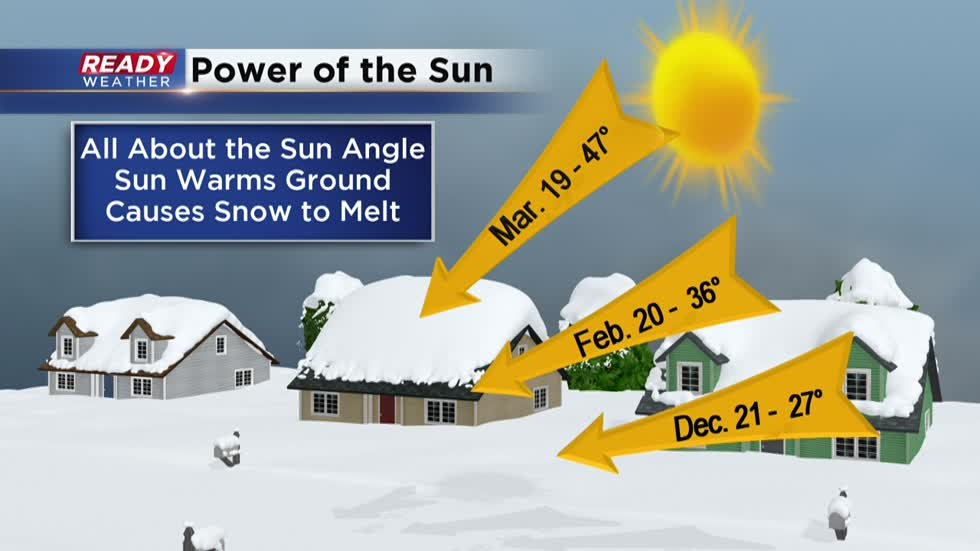
Now, even though highs will likely stay below freezing, I would expect for that wonderful snowpack to start melting today, why is that? The abundant sunshine tomorrow and the angle at which that sunshine is hitting this part of the earth will allow that energy from the sun to melt some snow regardless if it is below freezing.
Given the amount of snow on the ground around WABBLES and the limited time for sunlight at this time of the year, I don’t believe we will see all the snow melt today.
Yet Another Snow Chance?
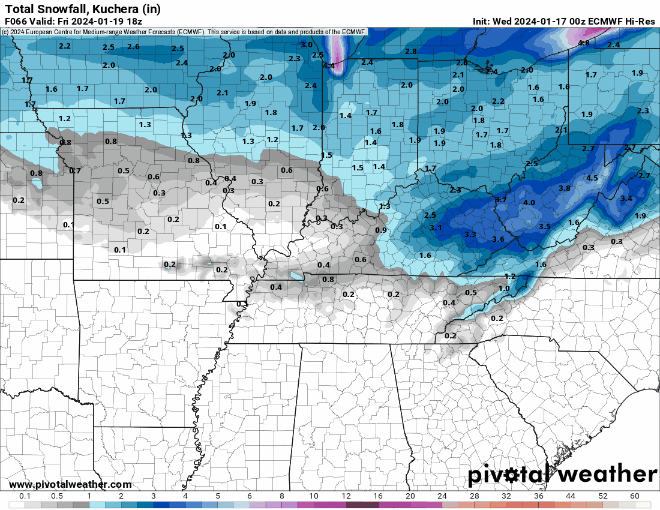
Models are eyeing yet another snow chance that looks to impact WABBLES sometime Thursday Evening into Friday Morning. As with every winter weather forecast, this one is far from easy (but definitely a lot easier than this last one).
Once again, the longer range global models and the shorter range hi-res models are in disagreement with yet another snow chance. This time, the global models are more aggressive with snowfall totals and the hi-res models have WABBLES getting next to nothing.
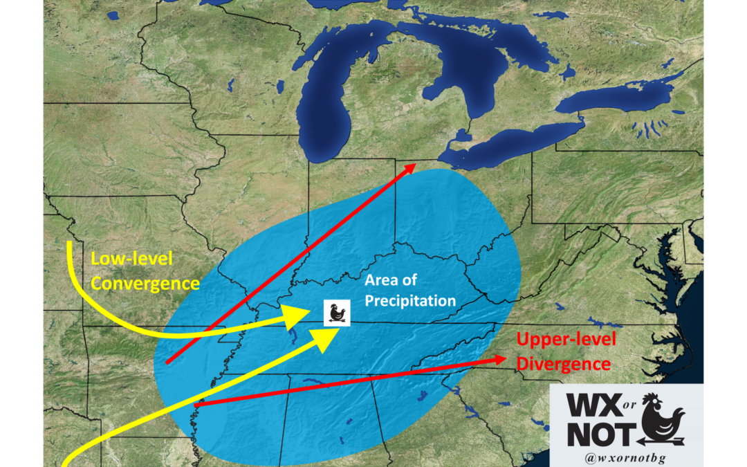
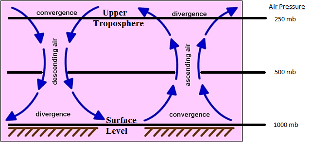
What the models are somewhat agreeing on, and I believe in, is a broad area of upper level divergence over WABBLES. Additionally, there looks to be a broad area of lower level convergence aiding in yet another snow chance.
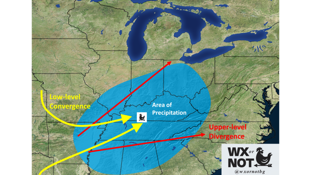
Both upper level divergence and lower level convergence are crucial and fundamental in the formation of yet another snow chance. You need the air closer to the surface crashing into one another so they are forced vertically and the air diverging aloft to aide in that rising motion from the surface.
So, the fundamental ingredient of lift will be in place, but what could get us in trouble and rob us of impactful snow is once again dry air with yet another snow chance. Since temperatures will be much higher for this system, the snowflakes will get made higher up in the atmosphere. They will then have to fall further to the ground where there are more chances of dry air evaporating the snow before it hits the ground.
Another factor is the potential presence of a “warm nose”, which could present a wintry mix of freezing rain/sleet/snow early in the event. This would obviously hurt total accumulations, as freezing rain & sleet doesn’t accumulate nearly as well as fluffy snow.
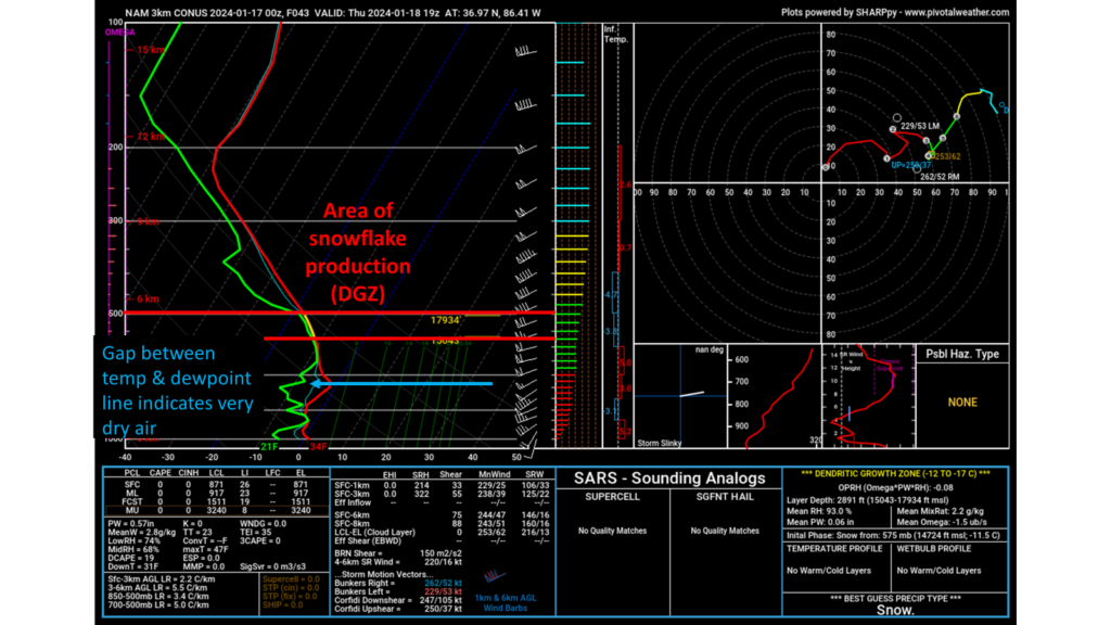
This, I believe, is a major factor as to why the hi-res models are saying WABBLES gets hardly any snow. Too much dry air throughout the atmosphere for yet another snow chance.
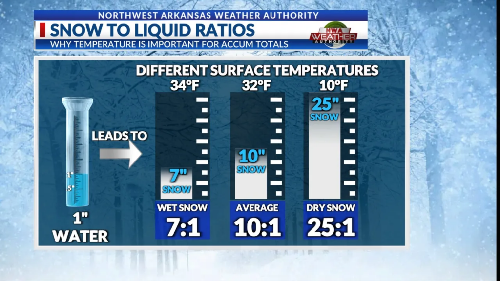
One last factor that needs to be taken into consideration with this forecast is the snow ratio we will be seeing. With this yet another snow chance, temperatures will be much closer to freezing resulting in a much lower snow ratio. This means that it will be harder to get higher snow totals out of a system.
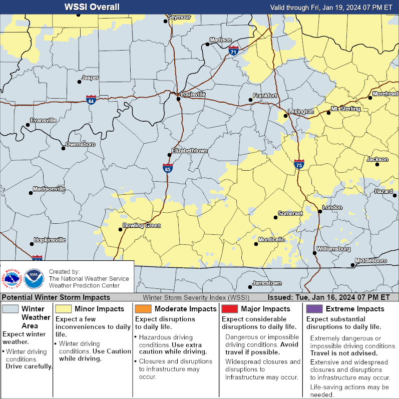
As far as impacts to daily life are concerned, that will largely depend on the amount of snow that melts today. If very little snow melts and we get an additional inch or more, we will see larger impacts than if it were just 1″ or more on its own. The Winter Storm Severity Index currently has parts of WABBLES in the “Minor Impacts” category.
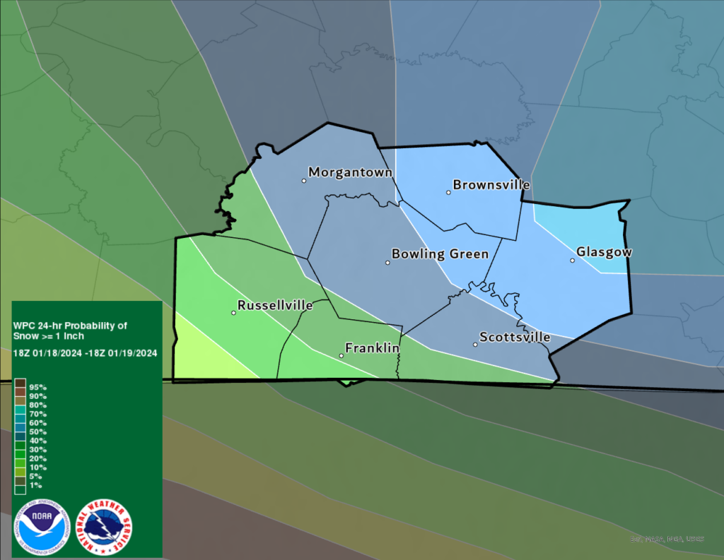
The WPC highlights the probability of WABBLES getting 1″ or more of snow with yet another snow chance. The probability ranges from as low as 10-20% for southwest WABBLES and up to 60-70% for northeastern WABBLES.
Perhaps what will be more dangerous than the upcoming snow is the additional arctic blast that comes with this system. We will begin to really feel it this Saturday before temperatures rebound to around freezing to close out the weekend.
With all that being said, here are my final forecast notes:
- Confident that WABBLES will see snow between Thursday Afternoon and Friday Morning.
- I am less confident on overall snow totals for the event.
- At this point, a dusting to 1″ (with locally higher totals) seems most likely.
- Dangerous cold to return Saturday.
That will be all for this blog post folks! I hope everyone continues to enjoy the snow out there and stays safe. For the latest on the upcoming system be sure to follow us on our social media accounts @wxornotBG.
Have a blessed day!
I love your guys weather posts and even an explanation, but this is very confusing and tough to read! A lot of stuff on here I and many others probably do not understand because it is way to technical. Sorry, just want to give some feedback on this person who keeps writing like this!