Happy Juneteenth, wonderful WABBLES family! We hope you are having a great holiday morning thus far on this pretty overcast Monday. Today’s big story is all about the spotty showers expected to linger in our area, keeping it rather damp through sunset tonight. But how long will those precipitation chances stay in town? Are we expecting to see any storms? The answers to all those questions and more will be revealed in today’s weather blog!

Today’s Forecast
Folks, you’re gonna want to keep those rain jackets handy today if you’re expecting to participate in any outdoor activities! Through late tonight, most of WABBLES will likely end up seeing a few rain showers or scattered thunderboomers, fueled primarily by this near-stagnant low-pressure system that is sitting directly over our heads and isn’t looking to move anytime soon.

While the GIF above loops through several days this week, the circulation of precipitation is obviously centralized around that center of low pressure, which will keep funneling showers and storms into the WABBLES area from the north through late this week. But because no explicit cold front is connected to the pattern, our temperatures here in Southern Kentucky won’t waver too much going into the week.
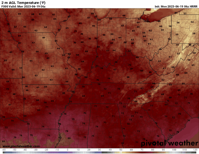
Most of us will see temperatures peaking around the low-80s through Friday, with our nighttime lows dipping down into the high-60s after sunset. Dew points are high for the entire state of Kentucky due to the continuous moisture being funneled out of the Gulf of Mexico, so it will definitely be muggy out there in between rounds of rain. Stay hydrated, stay dry, and stay indoors if a particularly bad thunderstorm makes its way into your neighborhood!
Wet Week Ahead
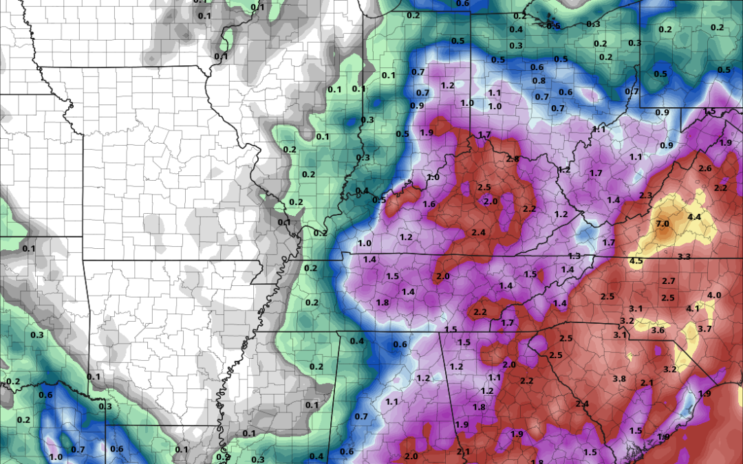
As discussed earlier in today’s blog, we are expecting this low pressure system to continuously bring precipitation chances to most of WABBLES through Friday. There is so much precipitable water in the air that any small disturbance could cause a localized shower or thunderstorm, and because we do not have a significant cold front to push it all out of the area, the wet weather will linger for a while. It’s definitely a far cry from the drier weeks of summer we’ve already seen!

The good thing is that this persistent rain may help to alleviate the dryness that seems to have permeated most of the state as of a few days ago! A majority of Kentucky, including WABBLES, is listed beneath an Abnormally Dry status, with areas in extreme western and central Kentucky solidly within the Moderate Drought criteria for mid-June. But this low pressure region is expected to bring anywhere from one to three inches of rain to a lot of these affected areas through the end of the week, so hopefully we may see some headway made against these drought-like conditions here at home!

Final Remarks
That’s all the weather we have for you today, WABBLES! Despite the cloudiness and wet weather chances, we truly hope you enjoy the holiday and are able to carry out all of your celebration plans unhindered. Remember to pack those umbrellas and rain jackets if heading out today, and maybe run a dehumidifier if it gets a little too sticky in your home. Until tomorrow, take care of yourselves, and we’ll see you with another forecast soon! Bye!