

")

It has been a hot and dry summer so far in WABBLES. And while your friendly neighborhood meteorologists have welcomed some clean radar sweeps following an almost stupidly active spring, we’re not huge fans of the drought status that’s been creeping in. However, it looks like we’ll get another opportunity for some shower and storm activity this weekend that should help put at least a small dent in the rainfall deficit.
Into the Weekend: Friday and Friday Night
Our next chance of rain isn’t too far away…but it’s just not here yet. But on the flip side, neither is the humidity.

Sunshine looks to continue as we head through the bulk of our day on Friday, though a few clouds may move back in as we head later in the day as moisture starts to move back into the region.
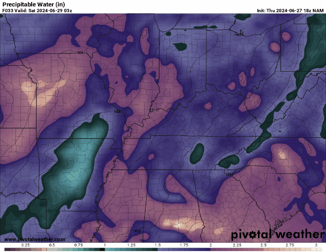
We’ve got the moisture in place Friday and Friday night, but no real trigger to get storms going. Ergo…we stay partly cloudy and muggy, muggy, muggy overnight. Lows will struggle to make it below about 75º or so.
Into the Weekend: Saturday and Sunday
Our next frontal boundary begins to work into the region as we head into the day on Saturday. At this rate, it would appear the day on Saturday starts dry. That will allow us to warm up quickly, getting highs into the lower to middle 90s as we head into the afternoon. Add in the fact that we’ll be quite humid, and that makes for a heat index of 100-105º.

As our front gets closer in the afternoon, we should start to spark off thunderstorms in the heat and humidity. We’ll be quite unstable, but the wind energy above our heads is lacking quite a bit. This means that outside of a collapsing storm providing us with the potential for a wet microburst, widespread severe weather is not expected.
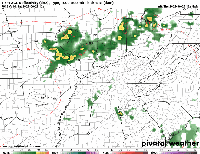
However, with quite a bit of moisture in the atmosphere and not much in the way of a steering current, storms may hang out over one location just dumping heavy rain. That could lead to some spotty flooding issues.
Showers and storms look to remain scattered about the region as we head through the overnight hours on Saturday. That should keep things rather muggy throughout the region as lows only make it into the lower to middle 70s.
Scattered showers and storms look to continue as well as we head through parts of the day on Sunday…mainly in the morning. Our weak frontal boundary should finally push through the region as we head later in the day. That will allow us to slowly scour out some of the humidity, and allow us too cool a touch. Highs look to stay in the upper 80s. Though, with the lower humidity values, we’re back into the lower 60s overnight as skies begin to clear.
Into Next Week
We’ll enjoy one of our recently patented “days in between” on Monday as high pressure scoots back in from the north. That will allow us to stay dry, sunny, and relatively comfortable as highs make it into the middle 80s. Things stay quiet overnight with lows back into the lower 60s. Dry weather continues into Tuesday, but we’ll make it another hot and humid affair as highs are back in the 90s and dew points back in the 70s.
That’s it for me for now! You can always keep up with the latest on all of our social media platforms. Have a tremendous day and a great weekend!