

")

We have been stuck in a late spring pattern this week here in WABBLES, and that looks to continue right on into the weekend as we will continue to dodge showers and thunderstorms.
Into the Weekend: Friday and Friday Night
Just when one system got out of here, we’re poised to watch another scoot into the region as we head throughout our Friday.
This system doesn’t have a lot of “oomph” with it for widespread severe weather or anything, but we will have to watch some of those scattered showers as they start to work closer to the region once again. However, I think our bigger concern will be repeated round of heavy rain as we watch showers push through.
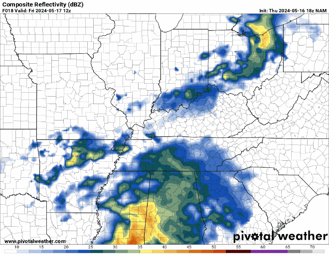
Said clouds and showers will also keep us cooler than we have been, with highs only peaking in the middle 70s during the afternoon. Some of those scattered showers could just continue into the overnight, with muggy lows only falling into the middle 60s or so.
Weekend Forecast: Saturday and Sunday
Just on the face of it, things already look much nicer on Sunday than they do on Saturday.

Our Friday system will have one a good job at cutting itself off from the flow of the jet stream, meaning we’ll continue to see repeated rounds of scattered showers and storms through Saturday afternoon.
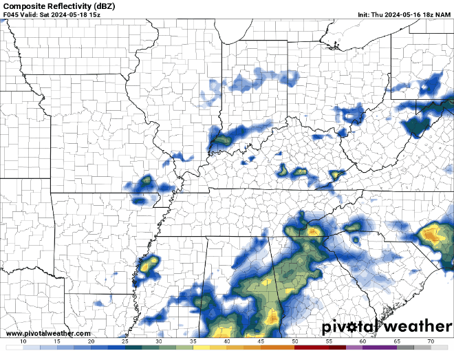
Again, I can’t rule out a strong wind gust or briefly severe hail, but the heavier rain threat looks to be larger than both if we wind up with storms that sit and train over the same areas during the day. Highs only look to make it into the middle and upper 70s thanks to the clouds and the showers. Overnight lows are back into the lower 60s as shower chances start to wane.
Sunday is our latest “day in between.”

A small area of high pressure will push into the region as we head into the day on Sunday ahead of our next system on Monday. This will provide us with mostly sunny skies to start, transitioning to partly cloudy as we head into the afternoon and evening hours. We’re still warm, with highs making it into the lower to even middle 80s as times during the afternoon. We should stay dry overnight as we slide back into the lower 60s.
Beyond the Weekend: Into Next Week
The nice weather looks to be short-lived as another system looks to scoot in here for the day on Monday.

That looks to bring a renewed opportunity for some afternoon scattered showers and storms, not unlike a normal summer pattern throughout the region. Highs will be warmer, looking to crest in the middle 80s. Some showers linger into the evening with the muggy environment as lows only fall into the middle 60s.
The active trend looks to continue as we head toward the middle of the week as the pattern turns slightly more favorable for storminess across the nation’s mid-section. Some of that may head in our direction as we head toward Tuesday and Wednesday, but it’s still too early to tell. Otherwise, we will continue the warm streak as highs start to top out in the middle and perhaps upper 80s.
That’s it for me for now! You can always keep up with the latest on all of our social media platforms. Have a tremendous day and a great weekend!