

")

Things have been fairly tranquil throughout WABBLES this week, but some more active weather looms as chances for springtime thunderstorms increase for this weekend and beyond.
Easing Into the Weekend: Friday and Friday Night
While the active pattern looks to return to the region…it doesn’t look to return for our Friday, with sunshine continuing throughout the region.

High pressure that’s been in place will continue to slither off to the east as we head through the day, allowing warmer air to begin to creep back into the region for the afternoon hours. Highs look to make a run up into the upper 60s to right around 70º or so.
The only thing challenging the sunshine’s dominance in the sky looks to be some high clouds starting to work in as we begin to work some moisture back into the region. However, overcast skies seem unlikely. We may even beef some of that coverage up overnight as lows fall back into the lower 50s during the overnight hours.
Easter Weekend: Saturday and Sunday
Far be it from me to suggest family plans for Easter, but it may not be a bad idea to move the outdoor Easter egg hunts from Sunday to Saturday, as this would appear to be the best chance at avoiding some potentially disruptive thunderstorms.

We’ll start the day on Saturday with some sunshine as high pressure begins to exit the region. We’ll be firmly in the southerly wind flow during the day as our next disturbance enters the picture to our west. Not only will this mean an increase an high cloudiness during the day, but also an increase in temperatures…yes, we’re talking highs in the middle to even upper 70s at times!
However, with an increase in temperature also comes an increase in moisture around the region, so we can expect those clouds to thicken as we head into the overnight and our next system starts to push in from the north and west. This should increase our opportunity for showers and a few thunderstorms overnight as lows only make it down into the upper 50s.
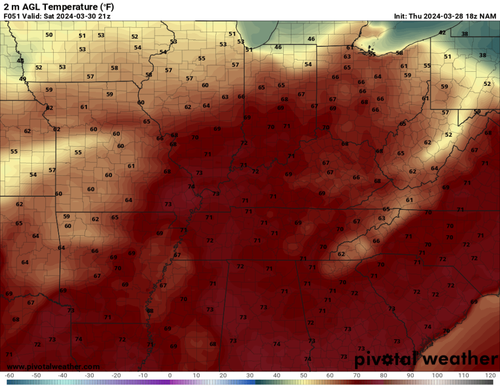
By Easter Sunday, we’re going to be keeping a keen eye on this boundary as it sinks southward through the region. We’re bringing up plenty of moisture from the Gulf of Mexico, along with highs making a run into the upper 70s to near 80º! This, interacting with the frontal boundary in the region, could spark off a few showers and thunderstorms, and I can’t rule out a strong storm or two, either. The question is where exactly is that frontal boundary when it gets here. The latest model runs are now taking it further into the north.
We slide back to calm conditions overnight as nightfall brings an end to our instability, but things stay muggy with lows back into the lower to middle 60s.
Beyond the Weekend: Through the Middle of Next Week
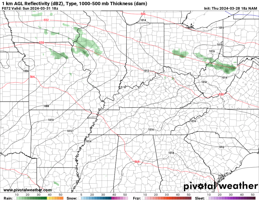
Still plenty of uncertainty in the forecast as we officially turn the calendar to April on Monday, but models continue to hint at the potential for some storminess as low pressure develops off to our south and west and tries to move up into the Great Lakes region.
We look to have plenty of wind above our heads as this low pressure gathers steam, in addition to plenty of moisture as our Sunday boundary moves back northward as a warm front. Highs on Monday look to make a run into the upper 70s to near 80º. The pattern suggests that we’ll have the chance for stormy weather, including the potential for strong to severe storms at times on Monday and even into Tuesday as this boundary moves through the region.
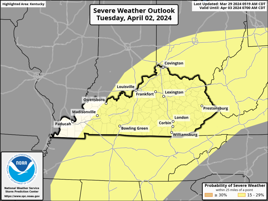
Right now, the best thinking goes that we could see some scattered storms Monday afternoon and evening, ahead of potentially strong storms late Monday night into Tuesday. However, if the storms do manage to move through overnight, severe weather looks less likely, but we’ll still be dealing with some heavy rain. However, if the storms manage to hold off until Tuesday afternoon, we could be looking at a larger severe weather threat.
However, there are still plenty of variables left to resolve as this pushes through…including timing. So, you’ll definitely want to check back in for the latest updates as we head through the weekend.
Trends after our storminess suggest we’ll be calmer and cooler for the middle and later parts of next week.
That’s it for me for now! You can always keep up with the latest on all of our social media platforms. Have a tremendous day and a great weekend!