

")

The WABBLES region continues to be soggy this morning as we watch our latest front push across the region. And while we’ve got rain and mild air in the region now, I think Old Man Winter’s got one more stand in him this month.
Entering the Weekend: Friday and Friday Night
Yes, those are likely some isolated rumbles of thunder you’re hearing out there through the early hours of our Friday as showers and storms push through. Don’t be surprised to see perhaps a strong wind gust or some small hail. However, widespread severe weather does not appear likely. Our highs are likely early in the day as week, with cooler air sneaking in after that.
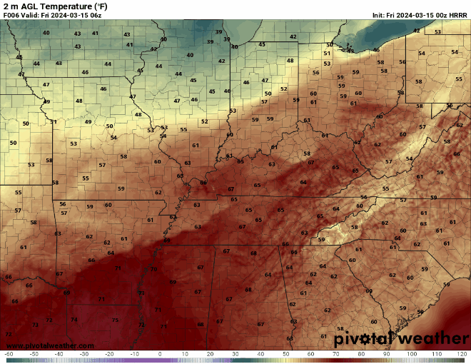
Rain chances will continue to wane as we head through the afternoon and evening hours as northwest winds bring drier and cooler air into the region. By evening and into the overnight, the rain should be gone. However, clouds will likely take a bit longer to clear the region. Even so, we’ll drop seasonably for lows down into the lower 40 to middle 40s through the overnight hours.

The Weekend: Saturday and Sunday
Weak high pressure begins to take over as we head into the day on Saturday, leading to a return of sunshine as air stays mild. We still end up with highs in the middle 60s as the chilly air holds off for one more day. Westerly breezes will make it feel pleasant out, however.

Overnight, we’ll continue to see a bit of moisture work into the region, adding to the few clouds that we will see after sundown. Those clouds will keep us from getting too cool as a weak disturbance pushes through the region. Overnight lows are only back into the middle 40s.
Temperatures don’t look to recover a whole lot into the day on Sunday, despite the sunshine.

That late Saturday/early Sunday disturbance will leave in its wake northwesterly winds that will really start to bring in much cooler than normal air. We should see some sunshine continue into the afternoon, but it will start to feel cooler as highs only make it into the upper 50s to near 60º. Not arctically cold, but still on the cooler side for mid-March, and it’s only getting colder from there.
Northwesterly winds will continue into Sunday night as skies turn partly cloudy with another disturbance pushing through. We’ll likely avoid much in the way of precipitation, but we will see the cooler air start to filter back in as we head into the overnight hours. Lows are back into the lower to middle 30s.
Past the weekend: Into Early Next Week
Things are turning distinctly cooler as we head into the early days of next week. However, the good news is that things look dry!

High pressure keeps us dry and cooler as we head into the day on Monday, with highs only making it into the upper 40s to near 50º or so. Overnight, clear skies will really help us cool down, with widespread frost a possibility as lows settle back into the middle 20s. We’ll only rebound into the 50s or so as we stay dry through the middle of next week.
That’s it for me for now! You can always keep up with the latest on all of our social media platforms. Have a tremendous day and a great weekend!