

")

Our weekend looks rather warm throughout WABBLES, but not nearly as active as our messy midweek. Even so, though, it appears we’ll have to dodge some showers before we can enjoy the warmer air.
Oh, and welcome to Meteorological Spring! We’ll have stats on how February and winter ended soon, but for our folks clamoring for warm air? We’ve got some good news!
Setting up the weekend: Friday and Friday Night
The latest weak disturbance to wet WABBLES appears to move in as we head through the early hours on Friday. There’s not a ton of moisture with this system, but it will attempt to move on into the region. That will lead to some scattered showers breaking out as we head through the morning and afternoon hours. The clouds and showers will keep us on the cooler side as we head through the daytime hours.

Friday highs only make a run up into the upper 40s thanks to the showers sticking around. The air remains on the cool side as well as we finish things off Friday night. Lows are only down into the middle 40s. At least the rain will be moving out!
Into the Weekend: Saturday and Sunday
Notice I didn’t mention the clouds moving out…because they don’t look to.
Clouds will hang tough on the back side of our Friday rain, but we’ll slowly work them out during the afternoon as drier air works in. This looks to be warmer air, too, as highs make a run back up into the lower to middle 60s, thanks to southerly winds!
It only gets better from there, too. After clear skies keep us in the upper 40s overnight, we get even nicer into the day on Sunday!
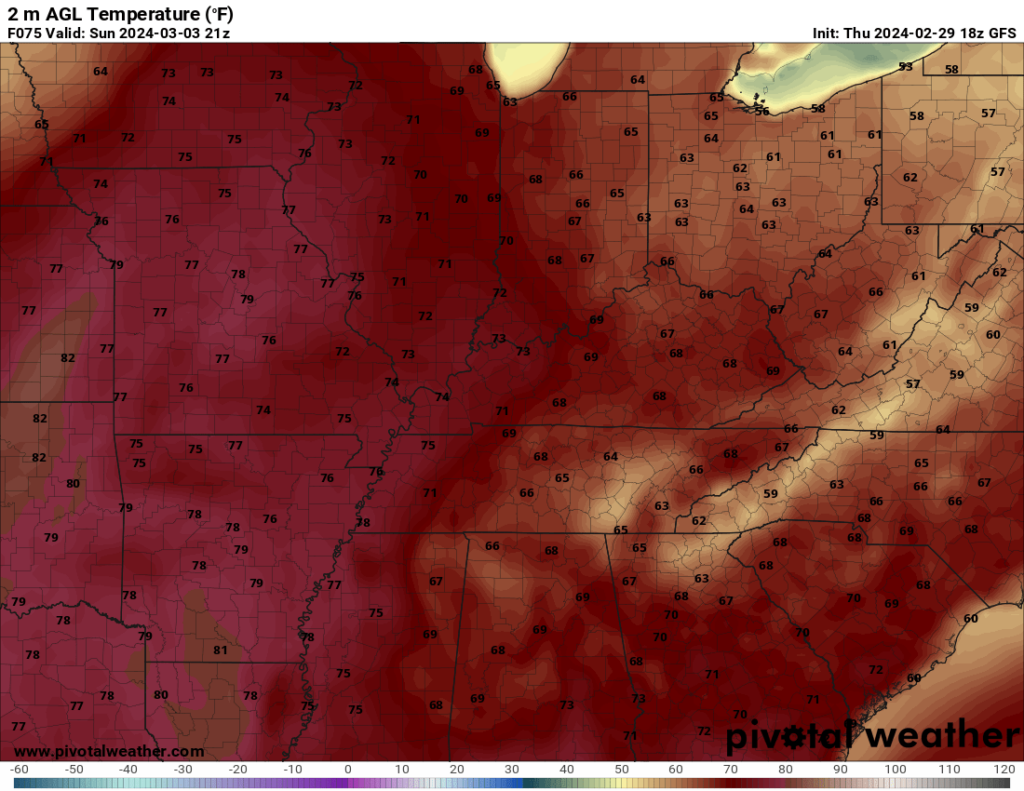
No, that’s not an old image. We’re talking highs in the lower to middle 70s! Under sunny skies, to boot! With not a term chance in sight! Definitely a day to get out there and enjoy. Lows only make it into the middle to upper 50s as a spring-like airmass continues to settle in.
Beyond the Weekend: Into Next Week
I think we’re starting Monday dry, but our next system is not too far away. We’ll see clouds increasing ahead of it as we head through the start of the work week. Even so, those clouds aren’t hurting temperatures at all. We’re still making it into the middle 70s during the daytime hours. Mid 50s expected overnight as well as showers continue to build.
And building to a rather soggy look to the midweek as we continue to see moisture push in from the west. Showers look to be in abundance as we head into the day on Tuesday as highs only make a run into the middle 60s. Now, this system has some moisture with it, so it wouldn’t shock me to see some swelling on a few creeks and streams, but widespread issues aren’t expected. At this point, we don’t expect to see severe weather either, but we’ll keep an eye on it.
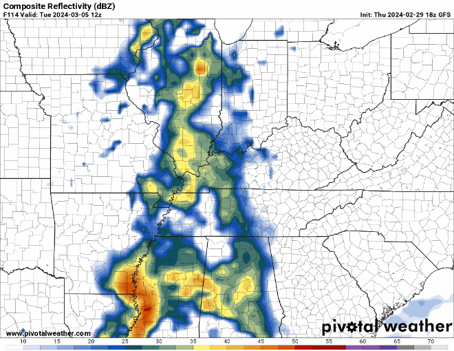
Some of those showers continue into the day on Wednesday, but we should start to cool down a bit as showers move out for the later portions of next week. Highs make another run into the lower 60s.
That’s it for me for now! You can always keep up with the latest on all of our social media platforms. Have a tremendous day and a great weekend!