

")

The weekend is upon us and, unfortunately, the pattern is looking a bit more active as we finish off this work week and beyond. Not only that, but it appears our above average temperature trend appears to be coming to a close soon.
Into the Weekend: Today and Tonight
Starting Friday off dry around WABBLES as we watch a system approaching from our west. We’ll be socked in with clouds as a few small showers continue to sneak in from the west during the day. Even with those spotty showers scattered about and the relentless cloud cover, we’re still looking mild for a daytime high thanks to gusty southwesterly winds. Highs look to top out in the lower to middle 60s with winds gusting 15-20 MPH at times.
Off and on showers look to continue as we head into the overnight hours as one impulse moves out and another works into the region. This one has a bit more “oomph” to it. A little more sauce if you will.

That will likely lead to more showers developing during the overnight hours and into the day on Saturday. As this system swings through WABBLES, we’ll likely see temperatures hold steady, if not rise, overnight. Lows only make it into the middle and upper 50s during the overnight hours as showers take over our weather picture.
Weekend Unfolds: Saturday and Sunday
Showers appear widespread as we head through the early half of the day on Saturday. Even so, breezy conditions at times will keep things rather mild throughout the region as highs top out once again in the lower 60s.

Here’s where things start to get interesting as Mother Nature sets up here next move.

This frontal boundary will cross the region late Saturday night and into Sunday. This will not only lead to showers tapering off as we head into the day on Sunday, but also the first wave of some cooler air pushing into the Ohio Valley. It won’t be super cold or anything, but noticeably so as we head into early Sunday morning. Lows are back…in the lower 40s.
Sunday itself is our day in between. Things look a touch cooler during the day with marginally chillier air, but we’ll also be getting influence from another low developing across the southern plains. We’re day during the daytime hours on Sunday, with highs making a run for 60º, but perhaps not quite getting there. The front begins to sweep through overnight Sunday and into Monday. More rain showers are likely with this system as it has more moisture to work with. Even so, we’ll start to feel the effect of another, even cooler airmass by the time we wake up on Monday morning. Meaning…we should wake up to lows in the lower 40s.
Beyond the Weekend: Through Early Next Week
Here’s where the interesting part comes in! As this system’s front pushes past during the day on Monday, we’ll see temperatures stagnate and fall back into the upper 40s to lower 50s for a daytime high. Depending on how fast we drop, we could be looking at a brief changeover back to some snow.
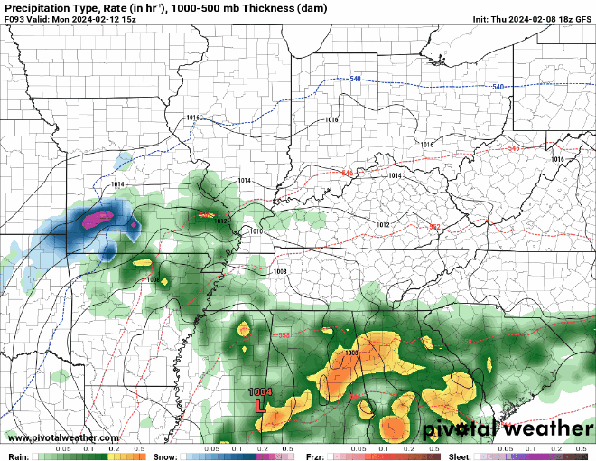
Don’t kill the messenger! Because we’ve been so warm and the ground has absorbed a lot of radiation from the sun the past week or so, it’s unlikely anything would stick. Even as lows fall back into the lower 30s overnight.
After that…well, trends are cooler, but sunnier as we head toward midweek and eventually Valentine’s Day. Highs are closer to average or slightly above in the upper 40s to near 50º, things look chilly and slightly below average with partly cloudy skies at night having us back down into the upper 20s and lower 30s. We’re keeping an eye as well on a potentially even more active pattern as we head deeper into the month…so stay tuned! We’re not done with winter yet!
That’s it for me for now! You can always keep up with the latest on all of our social media platforms. Have a tremendous day and a great weekend!