Good Monday morning, WABBLES! In case you’ve forgotten, it’s summertime, and this week is the perfect week to engage in some seasonal activities! Calm winds, bright blue sunny skies, and no precipitation expected; if you’ve been holding off on breaking out those slip ‘n slides or heading off to the lake, this week is for you! As we shift into a much drier weather pattern, you’ll want to trade in that umbrella for sunscreen if you plan to spend time outdoors. How long will our break from messy wet weather last? We’re going through it together in today’s weather blog!

Today’s Forecast
Today starts our perfect summer week, with high temperatures expected to top out in the low to mid-90s this afternoon. However, our feels-like temperatures will creep a little closer to the triple digits, so make sure you’re staying hydrated and slathered in some of that good sunblock to avoid any possible burns! We’ll be running this back nearly every day this week, with bright blue skies, light winds, and no real rain or storms forecast all the way into the weekend, when temperatures will drop ever-so-slightly.
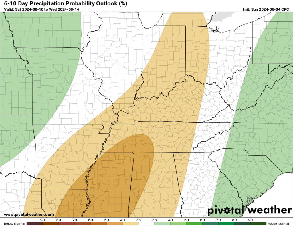
The Climate Prediction Center is quite convinced that this dry trend will continue for quite a bit, as their 6-to-10-day precipitation outlook places WABBLES squarely in the region expected to receive much less precipitation than is normal for this time of year. Below you can see the outlook for yourself, we aren’t lying!
Summer Weekend… COoldown?
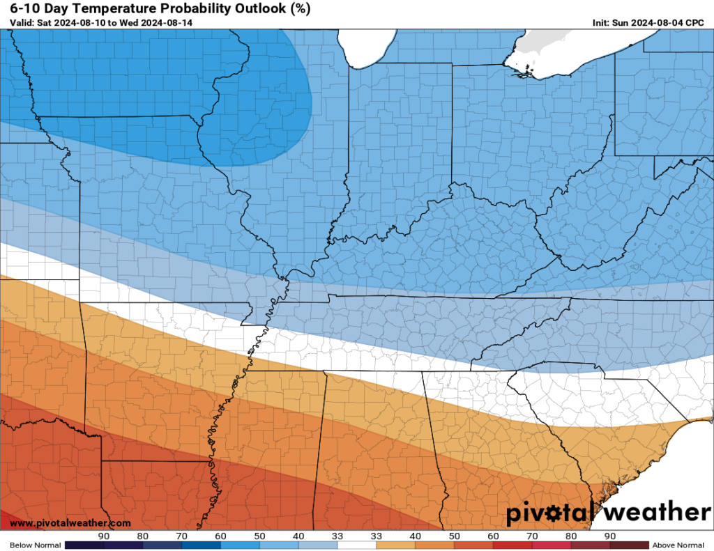
Oh, so you have been paying attention! We are expecting a little bit of a drop in temperatures as we get closer to the weekend, though at the moment there’s no precipitation expected with the system that’s ushering the slightly cooler temperatures in. And by cooldown, what we really mean is we’re taking a break from some of those mid-90s temperatures and trading them in for mid-80s, which isn’t necessarily cool, but definitely a departure from our current summer conditions!
In fact, the Climate Prediction Center once again has issued a temperature outlook for WABBLES which places our lovely area in a region of below-average temperature for the next 6-to-10 days. Don’t believe me? It doesn’t matter, we’re gonna show it to you anyway.
Other than what I’ve already offered you this morning… there isn’t very much to talk about when it comes to the weather! Category 1 Hurricane Debby made its landfall in Florida very early this morning, and while it’s forecast to bring a heaping amount of rain to some locations along the Gulf and Atlantic coasts, we’re currently not expected to experience any kind of troubles as a result of the weakening storm before it dissipates completely.
As for when some precipitation may return? The timing is currently unclear! Our weather models change and shift every single day, but we’ve moved into an upper-level pattern that’ll keep us from seeing any significant rainfall for quite a while. At the very least, our current summery conditions are expected to hold for the next seven days, with the possibility of our dry stretch extending out into midweek next week before we see any kind of relief.
That’s about all we’ve got for you today, WABBLES! It seems like a pretty picture-perfect summer week, but the weather forecast can change pretty fast, so make sure you’re staying tuned in to the blog here and to our Twitter page so that you’re getting the latest weather info as it happens! We’ll be back later this week for another in-depth blog going over what exactly you can expect this weekend, as well as our latest update on when this dry summer pattern might come to a close. Until then, take care out there y’all, and be safe!
