")
Good Monday morning, WABBLES, and happy July! It’s the first day of a brand-new month, and to celebrate, we’re diving into our weekly forecast… as usual. The good news is that things look pretty calm and comfy, at least before the midweek, when we may run into some issues closer to Independence Day. What kinds of weather are we expecting to see to kickstart July? And could Independence Day be a total washout? We’re going through it all together in today’s weather blog!

Today’s Forecast
But before we get into all that, let’s take a glance at today’s forecast! We are sunny, clear, and not expected to get too awfully hot here in WABBLES to start off the month, which is an absolute relief. We’re talking temperatures in the low 80s for highs today instead of mid-to-upper 90s, though they won’t stick around for very long. We’ll be sitting under an area of high pressure for the next few days, allowing some heat to build up in the WABBLES area and causing our high temperatures to inflate rapidly over a short time period.
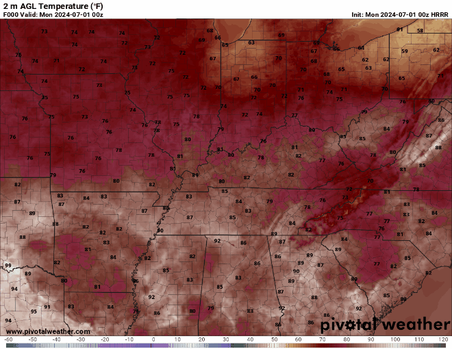
Don’t believe me? Today’s high temperature in Bowling Green is 81; but tomorrow? 94. That’s a thirteen-degree difference! It’s a good thing we’ll have an area of low pressure move through the region later this week to knock our temperatures back down a bit… unless you like cookouts and firework shows for your Fourth of July, unfortunately, because as with any new low-pressure system, precipitation chances are looking to become a bit of an issue.
Fourth of July Washout?
Okay, okay, maybe not a washout, but we’d be remiss if we didn’t mention how it looks like we’ll be seeing a cold front and its attached low pressure system work its way through the WABBLES area Wednesday night and into Thursday morning. We’re a little too far out for our high-resolution models to get a good look at what the storms could look like or exact timings, but what we do know is that showers and storms could move in during the early morning hours on Thursday and linger for most of the day before possibly clearing out around sunset.
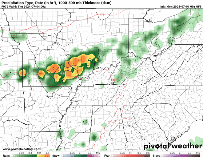
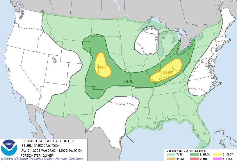
In fact, the Storm Prediction Center has already issued a Slight Risk (or a 2 out of 5) for severe weather a little ways to our north for the Wednesday night into Thursday morning timeframe, which we’ll definitely be keeping an eye on as we get closer to the midweek, because these outlook areas often change in size and strength as we approach the actual severe weather event itself. Will these storms ruin our Fourth of July? Right now it’s unclear, but things may dry out just enough to squeeze some fireworks and grilled hot dogs out of the holiday before it’s over.
As always, we’re going to stay on top of the forecast as we go throughout the week, y’all. If you don’t already, make sure to give us a follow on Twitter (or X, if you’ve started to embrace the rebranding, unlike us), where we’re committed to posting forecast updates in real-time every single day. We also broadcast early morning forecast breakdowns, so if you’re into waking up before the sun to get your meteorological fix, please check those out! Until next time, stay cool and dry out there y’all, and happy (early) Fourth of July!