")
Good Monday morning, WABBLES, and happy last day of March! Storm season is in full effect here in Southern Kentucky, and after last night’s round of severe weather, we’re here to keep you updated on everything coming down the pipeline. We’re in an active weather pattern at the moment, meaning that the time between storm systems has been reduced; as a result, we’re already eyeing our next potential disturbance, which is in line to impact WABBLES on Wednesday. Don’t worry! We’re going through all the details together here in today’s weather blog!
Today’s Forecast
But before we get into all the chaos of the week ahead, let’s take a peek at our Monday forecast! The good news is that we’re expecting a calm, cooler day across the WABBLES region in the wake of the system that pushed through last night. Even though storm season has absolutely arrived, these little breaks in between days of active weather will provide some solace, at least for a short time. Scattered cloud cover and highs in the mid-50s will be the story today as chillier air settles in behind all the rain we saw Sunday, but by tomorrow afternoon, we’ll be back to more seasonal highs in the upper 60s for most of WABBLES!
So… What’s That About Storm Season?
The high pressure that moved in on the backside of the last low pressure system will ensure we stay dry through Tuesday night, but the quiet period doesn’t last very long. A second messy system will arrive in WABBLES late Wednesday into Thursday morning, and though we’re concerned about severe weather with this wave too, one of our larger concerns is going to be flooding. Instead of exiting the region quickly (like the storms that moved through last night), our weather models continue to suggest that the frontal passage may stall over WABBLES, allowing storms and heavy rain to train over the region one after the other, all the way through Thursday and even a portion of Friday.
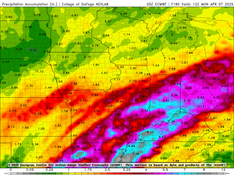
The above GIF is a loop of our EURO weather model through Thursday morning and into the weekend. While we’re expecting all hazards possible with this system as it pushes into WABBLES late Wednesday, the storms may quickly congeal into a line of heavy rainfall that’s expected to persist over the region for a while.
In fact, the Weather Prediction Center has outlined WABBLES in both the slight and moderate risks for excessive rainfall both Wednesday and Thursday of this week, speaking to their confidence in how we may see some significant flooding across the region as a result of this system. The EURO model’s estimation of how much rainfall we could see across the region through early next week is stunning, as some in WABBLES are highlighted near seven or more inches by Monday morning!
Confidence will grow a bit more in specific details about this system the closer we get to Wednesday, but for those of you who are in the habit of taking early precautions, now is the time. If you live in a low-lying area prone to flooding, brush up on those evacuation plans and know where to go in case a flash flood warning or even a flood emergency were to be issued for your area. In addition, everyone should be practicing severe weather safety as we get into storm season proper, because damaging winds, hail, and tornadoes will also be possible with this system!
No matter what, folks, we want you to stay safe this week as April kicks off with a bang. Severe weather season is no joke, and we’re here to walk you through it one day at a time. If you don’t already, make sure to give our Twitter page a follow; when we go live to cover severe weather, you can watch us there, as well as on YouTube and Facebook!
In addition, we post all the latest forecast updates there to make sure you’re as informed as possible before the foul weather arrives. And keep an eye on the blog here for more detailed breakdowns of what we’re looking at, as we post several of them a week to keep you in the loop on exactly what to expect.
Stay safe out there, y’all, and stay tuned! We’ll have more on this system in the coming days!