

")

It has been a long, hot, stormy summer throughout WABBLES. Most would imagine the hottest weather is yet to come, however, there’s a good chance that we’re looking at much cooler, drier, and sunnier weather as we head through this weekend.
Settling Into the Weekend: Friday and Friday Night
We’re watching yet another trough of low pressure head for the region as we head through the day today. Thankfully, we don’t have much in the way of moisture in place as it swings through, so we should continue our dry pattern into the afternoon as we look to be wedged between the trough to the north and Debby to the east.

We’ll look to see sunshine bump highs back up into the middle to upper 80s in many locations as cooler and drier air starts to filter in. That leads to the best four words a meteorologist can say in August: dew points are dropping.
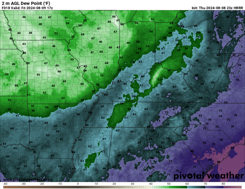
It will take a little big to see drier air during the day, but as we head into the overnight, we’ll see dew points make a bee-line for the upper 50s. That is simply exquisite. In fact, with overnight lows falling into the lower 60s, it might be time to let Mother Nature be your air conditioner as we head into the overnight hours!
The Weekend: Saturday and Sunday
It only gets better from here as we head into Saturday and Sunday. Canadian high pressure settles into the region, bringing us wonderfully sunny weather and even more brilliant temperatures.

Sunshine will continue to be in abundance as we head into Saturday afternoon. With that cooler, continental air in place, it looks like we’ll keep highs in the lower 80s as we head through the afternoon hours. Not too bad for mid-August! Dew points look to plummet into the 50s as well! So not only will we see abundant sunshine, but it will actually be comfortable to be outdoors!

Overnight, things stay seasonably cool throughout the region as lows fall back into the upper 50s to near 60º. Another night to potentially keep the windows open!
Carbon copy weather in place into the day on Sunday as sunshine and lower humidity continues throughout the region. Afternoon highs top out in the lower to perhaps middle 80s in our warmest locations. Dew points stay quite manageable, though, peaking in the lower 60s during the day. We’re slightly milder as clear skies continue overnight. Lows are back into the lower to middle 60s.
Toward Next Week: Warming Back Up
All good things must come to an end, and in August that means that nice weather typically doesn’t stay that nice for long!
However, Monday continues to look like another pleasant day of sunshine and highs in the lower to middle 80s and manageable humidity. Mid 60s with clear skies likely overnight.
High pressure does look to start moseying on, though, as we head toward the middle of next week. As it scoots east, we’ll start to see highs getting warmer as we re-establish our warmth and moisture pipeline from the Gulf of Mexico. I think each afternoon, we’ll end up with highs in the middle to upper 80s.

Models are also starting to hint at a potentially more active pattern heading our way, with our afternoon heat and humidity potentially fueling pop-up showers and thunderstorms each afternoon. Early indications are that these seem to be your typical “pulse” type storms that go up, rain themselves out, then go away. We’ll watch and see if that trend continues as we head toward next weekend.
That’s it for me for now! You can always keep up with the latest on all of our social media platforms. Have a tremendous day and a great weekend!