

")

Following Beryl barreling through WABBLES earlier this week, we have resumed the quiet weather…and that looks to continue right into the weekend. Only problem is that it will continue to be toasty.
Into the Weekend: Friday and Friday Night
Quiet conditions continue to dominate the weather picture as we head into the weekend. And you know what quiet means this time of year.

We’ll see temperatures back up into the upper 80s and lower 90s as we watch high pressure continue to exert its influence on the forecast. Not only that, but it should remain seasonably humid as dew points climb up into the middle and upper 60s for us.
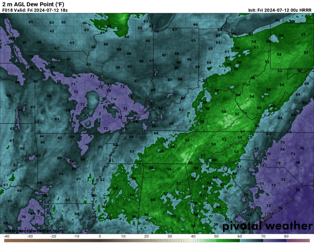
Not great to be outside in (unless you’re in a pool!), but typical of mid-July nonetheless.
Weekend Forecast: Saturday and Sunday
It’s what we call in the business a “persistence forecast” as heat and humidity continue throughout the region for the weekend.
Heading into Saturday, we’ll once again bask in the sunshine. That abundant sunshine should help boost those highs back into the lower to middle 90s or so. Dew points are back in the upper 60s, so it will certainly feel closer to 90º-100º out there. Yet another nice day to get in a pool!

Sunday looks to include more of the same as we continue to build the heat dome back across the eastern third of the country. That means we’ve got more hot weather on the way. Sunshine once again looks abundant as we head through the day on Sunday. Highs are back in the lower to middle 90s throughout the region.
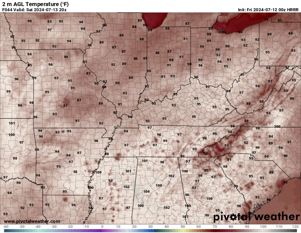
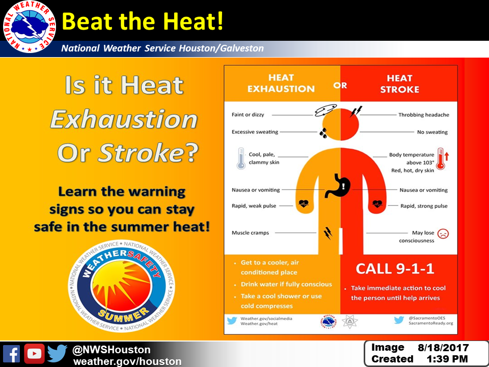
With dew points again near 70º, we’re looking at heat indices closer to, if not above, 100º or so. We’ll have to take those heat precautions if you’re outside this weekend. If you’ve got any yard work to get done, I would suggest doing it closer to sunrise or sunset, before or after the hottest part of the day. Wear light, loose-fitting clothing, take plenty of breaks in the shade, and drink plenty of water. Also, if you’re out and about, remember to ALWAYS check the back seat. Look before you lock!
Not a ton of relief overnight, with lows only falling into the lower to middle 70s as a few more clouds return to the region.
Beyond the Weekend: Hot again next week
The pattern continues to evolve as we head into next week and for us that means we’re getting hot again.
Temperatures will continue to surge into the middle and even upper 90s as we head into the day on Monday. Combine this with those dew points in the upper 60s and lower 70s and we’re potentially looking at heat indices near 100º or even 105º as we head into the afternoon. That’s close to Heat Advisory criteria and something we will continue to watch closely. Not a ton of relief overnight either, owe only fall into the lower to middle 70s.
The heat and humidity look to continue as we remain under the influence of this ridge of high pressure on Tuesday and Wednesday. We’ll be keeping an eye to our north as some storm complexes from the upper midwest may try to tumble our way by midweek. Either way, expect highs in the middle and upper 90s with those heat indices around 100º or so. So, I wouldn’t expect much of a break for the A/C anytime soon.
One thing we’ll have to watch by the middle and later part of next week is a pattern setting up that could bring us the potential for showers and storms at times in complexes that drive out of the north and west. It’s something we’ll continue to watch…because it’s not like the rain is unwelcome.
That’s it for me for now! You can always keep up with the latest on all of our social media platforms. Have a tremendous day and a great weekend!