

")
HYPERLOCAL WEATHER FOR WARREN, ALLEN, BARREN, BUTLER, LOGAN, EDMONSON AND SIMPSON COUNTIES.
The Latest WABBLES Forecast
WABBLES Twitter
It won't rain all day everyday, but if you have outdoor plans this weekend, Saturday looks like the better day.
Let's break it down:
WABBLES Weekend: Brief break in the active pattern - WXorNOT
If you’ve been searching for pool time this week amid the widespread rain chances in WABBLES, I finally have a...
wxornotbg.com
Weather 7.26.2024
The mugginess you're used to, with perhaps a shower or storm before midnight.

A mix of sun & clouds on the docket today; a few storms can't be ruled out, thanks to a cold front passing through from the north.
Now 70˚ / High 87˚
Weather 7.25.2024 https://x.com/i/broadcasts/1eaKbaEYOQaxX
Beautiful sunset tonight in Southern Warren County!! @I65WxSils @wxornotBG @Kentuckyweather @DavidWolter1 @WBKOWeather @Richgreg70


WABBLES Weather Blog

Whether the weather be fine, Or whether the weather be not, Whether the weather be cold, Or whether the weather be hot, We’ll weather the weather Whatever the weather, Whether we like it or not!
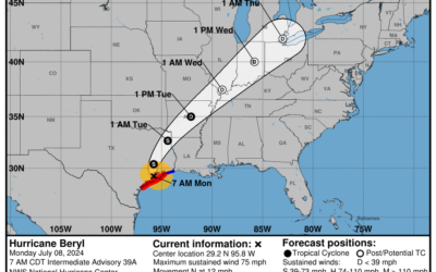
Jul. 8th; Tropical Trouble Likely Tomorrow as Beryl Arrives
Good Monday morning, WABBLES! We're in for a wild week of tropical weather as Hurricane Beryl has...

WABBLES Weekend: Pool weather to close July 4th weekend
Our Fourth of July weekend started off on a soggy and stormy note around WABBLES. Thankfully,...

WABBLES Radar
WABBLES RADAR: Stay one step ahead of the weather with our up-to-date radar, providing you with accurate and timely information about incoming storms and precipitation patterns in the WABBLES region.
WABBLES Skycams
WABBLES SKYCAMS: Explore the beauty and power of the weather through our SKYCams placed strategically in local communities. See the storms rolling in and get a real-time view of the ever-changing sky. Our SKYCams capture the essence of the weather, allowing you to witness its awe-inspiring moments firsthand.
Our Team
OUR TEAM: Meet the passionate and dedicated meteorologists behind Weather or Not. Our team brings you accurate forecasts, valuable insights, and a touch of humor to make your weather experience informative and enjoyable. Get to know our meteorologists and discover the faces behind the forecasts.
Advertise With Us
ADVERTISE WITH US: Want to reach a weather-savvy audience in the WABBLES region? Advertise with Weather or Not and showcase your brand to a community that relies on accurate weather information. We offer tailored advertising solutions to suit your needs and help your message make a splash.
WABBLES WEAR is here!
Introducing WABBLES Wear:
Where Weather Meets Wearable!
We are your one-stop shop for weather-inspired fashion that’s as unique as the ever-changing sky. If you’re a true WABBLES enthusiast, our merch is your passport to showcasing your love for this vibrant region in style.
Contact WXorNot
Have a question? Want to have a speaker about the weather in your area? Give us a shout.