

")

We’ve spent this a-here first week of June slowly getting back into a rather stormy pattern around WABBLES, and as we finish it off and head into the weekend, we may have more than one round of storms to contend with.
Peak Storminess: Friday and Friday Night
We’ve been easing into a more summerlike weather pattern as this week has progressed, and that also extends into our storm chances.

Up above our heads, the jet stream has been getting into a more “zonal” configuration or, simply, some straight up west to east winds. This will overlap with plenty of heat and humidity streaming up from the Gulf. The only thing we need is a trigger and we’ll likely see that in the form of several smaller disturbances that will kick off showers and storms, especially out to the west during the day.
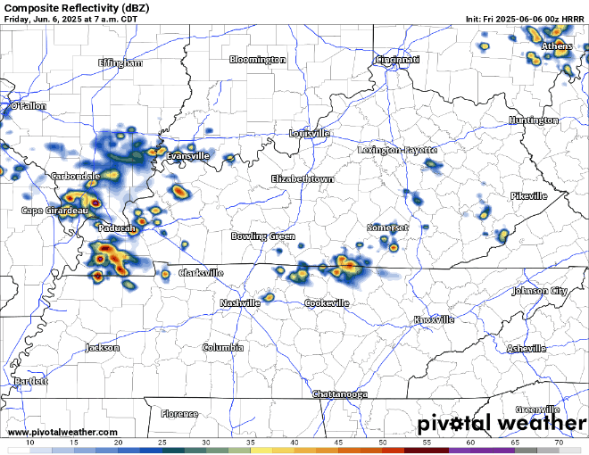
These storms will likely be encountering quite the warm and humid environment as highs will likely get up into the middle and upper 80s during the afternoon, with dew points climbing up into the upper 60s to near 70º. In short: air you can wear.

Any storms that we see, especially if they can group together into a big ol’ complex of storms called an MCS (mesoscale convective system), will have the capability of producing damaging winds and some hail. While we aren’t really seeing the ingredients in place for tornadoes, we can never rule out a brief spin-up in these scenarios, especially where some of the cells can merge together or hitch their wagons onto a boundary. We’ll have the latest on our severe weather risk categories and trends on all of our social media platforms, so check back frequently!
Heavy rain will also be a distinct threat, if not the biggest issue, thanks to all the tropical moisture in place. As always, #AvoidFairview.
We’ll have to keep an eye on those storms as they push off to the south and east during the evening and into the overnight hours. Even as storms depart, it looks to remain warm and muggy overnight, with perhaps some showers lingering. Lows are back around 70º.
Summer Keeps on Summering: Saturday and Sunday
Saturday’s weather remains highly variable, because it all depends on where that pesky cold front wants to set up shop.

If Friday evening’s storms are able to drag that cold front further to the south, while we would likely see showers in the morning, we’d be in for a pretty nice day!

However, if the front decides to hang up in the region, we’re probably in for another round of showers and storms, some of which could be briefly strong with some gusty winds a possibility.

Outside of any storms, a break in the action should help highs get back up into the lower to middle 80s during the afternoon hours. Showers and storms should start to wind down heading into the overnight hours, with lows falling back into the middle 60s.
We may be able to squeeze another break in as we head into the day on Sunday as we’ll be in between disturbances during the day. This should lead to some sunshine and perhaps slightly lower humidity during the day.

I can’t completely rule out scattered showers, though, so don’t be shocked if your outdoor plans get briefly disturbed. Outside of that, it’ll feel pretty nice as highs are back in the lower 80s. Overnight lows are back in the middle 60s as we clear things out.
Shifting the Pattern Around: Into Next Week
We’ll keep the break around for a bit, but another weak disturbance looks to try to crash in here as we head into the early part of the work week.

That could lead to the return of showers and storms as we head into our Monday afternoon. As usual, some of them may collapse with some occasional gusty winds and heavy rain, but widespread severe weather is not expected.

Outside of storms, we’re warm, humid, and partly cloudy with highs back into the lower 80s. Overnight lows are back into the middle 60s as the summertime pattern really takes hold.
All depending on the speed of the front pushing through, we may see some improvement during the day on Tuesday, though I still can’t rule some showers out. That may lead us to some slightly nicer and less humid weather as we head through the middle of next week, with highs closer to the lower 80s.
That’s it for me for now! You can always keep up with the latest on all of our social media platforms. Have a tremendous day and a great weekend!