

")

What we have feared may occur across the WABBLES community appears to have come to pass on this Sunday morning. Between 8 and 12 inches of rain that has fallen over the past week has driven area creeks and streams well out of their banks, with top five all-time crests expected for parts of our area.
The Rainfall
Thankfully, our frontal boundary is finally getting on out of here, taking with it the extraordinary amount of rainfall we have seen this past week. Still, though, Mesonet stations throughout our area have shown utterly incredible rainfall totals over the past five days.

The Mesonet station in Butler County officially topped one foot of rain early on Sunday morning, with a 12.02 inches total. The Logan County station near Russellville “only” received 11.23 inches of rain. The stations in Warren County, and on the Barren County line topped 9.5 inches, with the station at the WKU Research Farm flirting with ten inches of rain. The Scottsville station measured a hair over 8 inches, while the station in Simpson County near Franklin topped out at 7.39 inches.
To put that in perspective, the NWS Louisville climate site at Bowling Green-Warren County Airport usually averages 4.81 inches of rain for the month of April. We received more than double that in the first five days. The 10.04 inches of rain received at the airport the last five days beats the previous 5-day record (9.37 inches) set during the flooding in early May 2010. Just 6 days into the month, Bowling Green is already at the fourth-wettest April in its history.
Let’s dive into the impacts.
Green River at Woodbury
As of Sunday morning, the Green River in Woodbury is in MAJOR FLOOD STAGE.
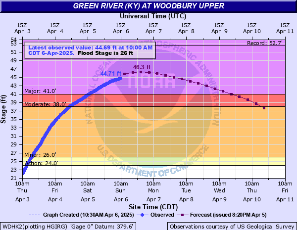
The river was measured at 44.71 feet at around 10:00am Sunday morning, and is forecast to crest Monday morning at 46.3 feet. While that is not the record (52.67 feet during the historic 1937 flooding), a crest north of 46 feet would qualify for the fourth highest crest of all time. The river is not forecast to fall below major flood stage (41 feet) until some time on Wednesday.
We have received numerous reports and photographs showing the flooding in the region.
It should go without saying at this point, but apparently not. NEVER, AND I MEAN NEVER, DRIVE THROUGH FLOODED ROADWAYS. It only takes between 6 and 12 inches of flowing water to sweep your vehicle off of its tires…now you’re flooding in a swollen stream and emergency services have to stop what they’re doing to help you who apparently couldn’t help yourself.
Green River at Rochester
Downstream at the Rochester Dam, current location of John Prine’s soul, it is in MODERATE FLOOD STAGE this morning.
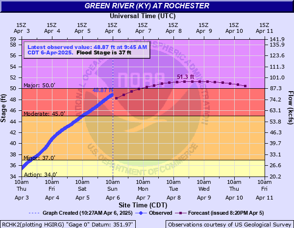
The river was measured at 48.87 feet around 9:45am on Sunday. It’s forecast to rise above 50 feet and into major flood stage by Monday morning and crest at 51.3 feet sometime on Tuesday. While this is more than 10 feet below this historic crest of 61.6 feet from the 1937 flooding, 51.3 feet would be good enough to make it the third highest crest on record, besting the 51.18 feet back in 1962. For perspective at 47 feet, Rochester is cut off and at 50 feet, water approaches the first floor of homes in town, along with closing several county roads.
Green River at Mammoth Cave
While the focus has been on the serious flooding ongoing across Butler County, more flooding is expected downstream at the Mammoth Cave gauge.
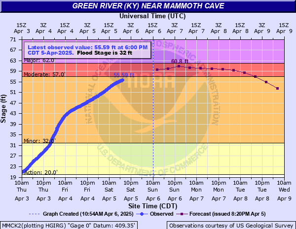
The river was last measured at 55.59 feet late on Saturday evening. That puts the Green River at Mammoth Cave into minor flood stage, but flirting with moderate flood stage (57 feet). Of note, the record crest is 52 feet during the historic 1937 flooding, so we have already blown past record crest It’s expected to rise into moderate flood stage some time on Sunday, and crest near 60.8 feet later on Sunday night.
Barren River at Bowling Green
Moving into Warren County, while the Barren River remains elevated, at this point it appears that we will avoid not only a record crest, but also even major flood stage.
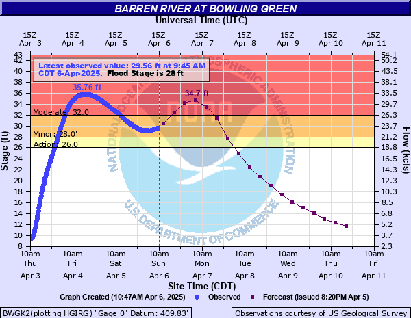
The river was measured at 29.6 feet at around 10:00am on Sunday, putting it back into minor flood stage following an earlier crest in moderate flood stage on Friday. However, it is forecast to rise again into moderate flood stage during the day on Sunday, and getting back up to 34.7 feet sometime early on Monday, before receding again. If that 35.76 foot crest on Friday holds as the high water mark for this event, that would put this crest somewhere near 20th all time at this gauge. This isn’t approaching record territory in Bowling Green, but it’s still not something to mess with, especially with several roads closed in the area.
Drakes Creek near Alvaton
The last gauge we have in our region that’s in flood stage is out near Alvaton along Drakes Creek.
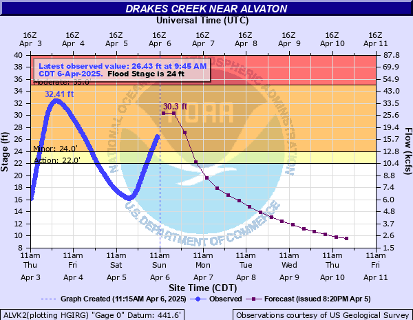
It was measured Sunday morning at 27.11 feet, which puts it in minor flood stage. The creek last crested back on Friday morning at 32.41 feet, which is in minor flood stage, and a little less than 10 feet below record crest. The creek is expected to rise again to about 30.3 feet sometime on Sunday. Again, this is not significant flooding, but if the Friday crest holds, that will place it at about 8th on the all time list, right below the crest on New Year’s Day 1937 (32.47 feet).
Throughout Kentucky
Obviously, the flooding is not confined just to the WABBLES region. The flooding effects have been far and wide.
In Louisville, officials canceled the annual Kentucky Derby Festival Thunder Over Louisville fireworks and airshow that was to take place next Saturday, April 12, due to the impacts the swollen Ohio River would have on safety of exhibitors and visitors.
The cancellation marks the first time in the event’s 34 year history that it had to be canceled due to weather, which is no mean feat if you’ve lived in the Ohio Valley for much of that time.
On one of the Ohio’s tributaries, the Kentucky River in Frankfort (full disclosure, this author’s hometown), flooding was much more significant. The Kentucky River at Frankfort Lock 4 is expected to crest at 49.5 feet early on Monday, more than a foot higher than the previous record crest during the area’s previous worst flood in 1978.
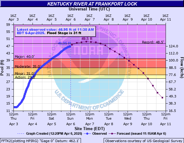
The famous Buffalo Trace Distillery is located on the banks of the river and was experiencing significant flooding on Sunday morning.
Additionally, parts of downtown Frankfort are reportedly being sandbagged to prevent higher rises of water into town.
What’s Next?
Well, outside of some light showers through the afternoon, we should begin to dry out quickly over the next several days. That should allow local creeks and streams to start to fall as the bulk of the water heads downstream.
Our biggest concern over the next few days is going to be the cold, with freeze watches in place that agricultural interests that need to pay attention to.
Sunshine and cooler temperatures should return for Monday and Tuesday. We’ll try to moderate ahead of some lighter showers working our way in our northwest flow pattern by the end of the work week. We’ll have a brand new blog with the latest on a more tranquil forecast coming up in the morning.