

")

Following an unsettled, yet still rather benign weather week in WABBLES, the pattern looks to stay on the active side as we head into the weekend, which could provide us with an opportunity for strong to severe storms.
Warming Up: Friday and Friday Night
Effectively, the first warm front for our weekend storms moves through during the day on Friday.

This pattern change will finally kick our northwest flow pattern to the curb and allow warmth and moisture from the Gulf to surge up into the Ohio Valley.
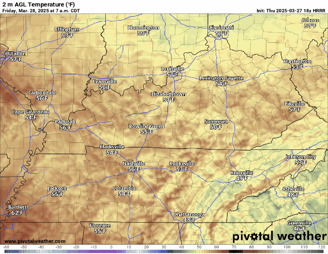
Some showers may linger early in the day, but we may actually see a drying trend as we head later into the day. The southerly winds and sunshine should help boost highs up into the middle and upper 70s during the afternoon…and I’m not ruling out that someone could flirt with 80º.

Clouds continue to filter in ahead of our next disturbance that should work in on Saturday. We may even see a few showers during the overnight hours. Lows are mild, hovering around 60º.
Shower Chances to Storm Chances: Saturday and Sunday
A weak disturbance from the southern stream will work in as we head into the day on Saturday. This will likely bring us some showers.

Clouds will be in place through much of the day on Saturday, which should keep us mild through the morning and into the afternoon hours before showers break out.
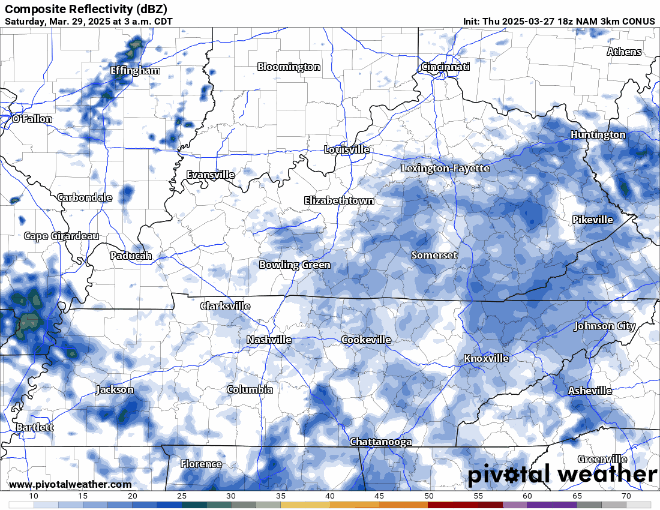
It shouldn’t rain all day, nor is the rain looking to be particularly heavy, but it is something we’ll have to deal with during the day. Clouds and showers should keep highs from getting too warm, but mild southerly winds should keep highs around 70º. Showers should slowly work out overnight as lows fall back into the lower to middle 60s.
We’ve been watching Sunday like a hawk for the entire workweek now, and that day represents our latest best chance for strong to severe storms. Models are continuing to hone in on a solution. The current thinking is that with plenty of storm fuel in place and a strong system moving in, we will likely see severe weather pushing through sometime during the evening or early overnight hours.

Right now, it looks like storms will pop to the west of the region across the Mississippi Valley, where they may have the greatest potential to produce severe weather, before congealing into a line that will try to sweep across the region. The main threats appear to be the potential for damaging winds, heavy rain, and large hail…but I think we’ve got just enough spin in the atmosphere that we’ll have to watch for an isolated tornado or two.
Of course, none of this is set in stone. We will continue to refine the forecast, expected threats, and the threat areas as we head through the next couple of days. Check back on our social media channels often for the latest updates, including SPC risk areas.
Into Next Week: Only Done Temporarily
Once the main storms pass by early Monday morning, we’ll get to enjoy a break, at least for a couple of days.
We’ll dry out and cool down a little bit, at least for Monday and Tuesday. Highs look to settle back into the lower to middle 60s, with drier air allowing lows at night to fall back into the 40s on Monday night. Tuesday night may be a little milder, with lows only settling back into the 50s ahead of our next active period.

Models have been hinting at another system, perhaps more than one, working into the region as we head toward the latter part of next week. Some have been focusing on Wednesday, some on Friday, some on both. Either way, we’re likely going to have to watch this time period closely, as it will be accompanying another warmup back into the 70s that could mean a renewed threat for strong to severe thunderstorms.
‘Tis the season, I suppose, but darn if I’m not already tired of it.
That’s it for me for now! You can always keep up with the latest on all of our social media platforms. Have a tremendous day and a great weekend!