

")

Winter tried to make another appearance in WABBLES this week, but the big story will continue to be the potential for heavy rain this weekend and beyond.
Juicing Up: Friday and Friday Night
Valentine’s Day couldn’t be hitting at a better time in our active pattern. The perfect time to slow down and spend the evening with the one you love.

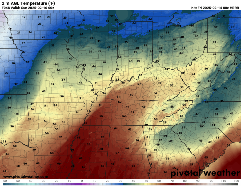
We’ll keep things around average during the day on Friday as we see a mix of sun and clouds during the daytime hours. That should keep highs right around or just above where we should be for this time of year, with readings topping out in the middle and upper 40s. However, that’s ahead of big changes.

During the day on Friday, we’ll watch moisture stream in from the south as a low pressure develops across the southern plains and starts to deepen as it moves east. For us, this means increase in high cloud cover during the day, with thicker cloud cover overnight. In fact, we may even see the return of rain showers as we head into the overnight. And yes, even as lows top out in the upper 30s. That’s all setting the stage for yet another soaker as we head into the weekend.
#AvoidFairview: Saturday and Sunday
Just going to open up with this one.
That low pressure developing across the southern tier should begin to work into the mid-south during the afternoon and evening on Saturday. This look to be a rather dynamic system, which will draw up plenty of warm air and moisture across the southern states.

For us, while we’ll see some slightly warmer air, the big story is going to be the moisture. Scattered showers will begin to break out across the region during the early hours of Saturday. Even with the showers, you should expect highs to soar back up into the upper 50s to near 60º during the afternoon and evening hours.
While this storm system will likely have a severe weather threat associated with it, that risk looks to stay confined to the south of us, mainly across Mississippi and Alabama, though I can’t completely rule out the potential for a strong wind gust or two.
The main issue with this system for us is going to be a tremendous amount of rainfall as this system moves in.
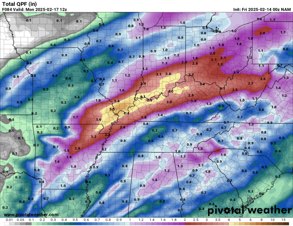
Moderate to potentially heavy rain could drop upwards of 2-4 inches of new rainfall on the area. Not only could that lead to ponding of water on roads, parking lots, and other well-known areas (cough #AvoidFairview cough), that will likely lead to rises on creeks, streams, and rivers. If you live in a flood-prone area, this is a forecast you are going to want to pay attention to!
These rain showers will look to continue pushing through the region during the evening and overnight hours on Saturday as lows fall back into the middle 30s behind the front.

Take this time on Friday, before the rain starts, to go over your flood safety plan. Know what to do and where to go if high water threatens your location. And always, if you see floodwaters over a roadway, TURN AROUND, DON’T DROWN.


This system looks to take its sweet time pushing out of the region on Sunday, leaving moisture left over as colder air begins pushing into the region…and you know what that means…

I’m not expecting a big thumping of snow, but we could finish this thing off with a few flurries before the precip machine shuts off and we try to clear out. Highs stay in the lower to middle 40s. We should start to clear out overnight, allowing much colder air to filter in, with overnight lows perhaps collapsing into the upper teens to near 20º.
Winter’s Not Done: Into Next Week
You know, I wouldn’t blame you for thinking perhaps we’re finally starting to break out of winter’s grip, with us heading into the second half of February and our recent rain events. But Mother Nature’s here to say we’re not done with her pal Old Man Winter yet.

Though, mercifully, we will get a bit of a break from the active pattern on Monday, but things will remain chilly during the day, despite the sunshine. Highs only make it up into the middle 30s, though overnight clouds should keep us from getting much cooler than the middle 20s overnight.
One thing we’re going to have to watch is our unsettled pattern trying to get cranking again toward the middle of next week. We’ll have more than enough cold air in place.
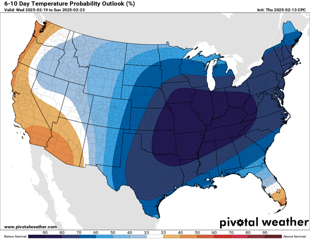
That means that if we can get a system with some moisture in here, it won’t take much to squeeze out some snowflakes, and quite a few at that. There are plenty of details to iron out before this becomes worth diving into, but just keep in the back of your mind that winter’s not over yet.
That’s it for me for now! You can always keep up with the latest on all of our social media platforms. Have a tremendous day and a great weekend!
My new go to site for EdCo weather!!