The holidays have come and gone and I hope everyone in WABBLES enjoyed the much above average temperatures. Old Man Winter has moved into the region, brought his bags, and is ready for a long stay as the second month of Meteorological Winter has arrived.
Snow Shower Chances: Friday and Friday Night
Cold air has already settled into the region late this week, and that means that any weak disturbances could be efficient at dropping a little bit of snow on the region.
We’ll watch precisely that as we head through the early hours of our Friday. A weak clipper may try to drag a swath of light snowfall through the region early this morning into the midday hours, though it looks like the best chance should stay across Central Kentucky.

Either way, we should see at least a little sunshine in the afternoon, though that won’t help temperatures much. Highs only look to make it into the middle and upper 30s. That cold air on the back side of this front is no joke.
The clear skies overnight will allow what little warmth we got from the sun during the day to escape out into space at night. Overnight lows are around 20º, with your sheltered valley locations likely dipping into the upper teens.
Half and Half: Saturday and Sunday
The weekend, as all do, will have two halves…but man, do those halves have big differences.
Let’s dispense with Saturday quickly, because we’re not expecting much in the way of impacts for the first half of the weekend. We’ll see sunshine early in the way, with a few clouds trying to sneak in as we get toward sunset. Highs stay in the middle 30s, with overnight lows still making it into the lower 20s.
Now the big weathermaker.
Models have been hinting at the potential for a strong system working its way through the Ohio Valley for the better part of a week now, and it looks like it’s headed right in our direction. With cold air in place…things get a whole lot more interesting.
Low pressure looks to form across the front range of the Rockies and eject out into the plains starts through the start of the weekend. Models are coming to the consensus that our area could be in what’s known as “the battle zone.”

What’s happening here is that we’ve got at least a shallow layer of cold air at the surface, at or just above freezing. However, as precipitation moves in early in the day on Sunday, we’ll introduce not only an influx of moisture, but also an influx of warmer air above our heads. This means that the frozen precipitation falling up where the jet airplanes fly melts on its way down to the ground, but has the potential to re-freeze when it hits the surface…freezing rain.
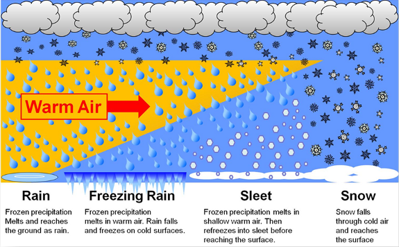
Now, there is still some uncertainty on the exact track of the system as it moves toward our area. Models have been taking the low from southern Missouri, right over us, and then on toward southeast Kentucky. This course would leave us with mostly sleet and freezing rain…which is no fun at all.

However, since it’s not set in stone, any deviation in the path of the low could drastically impact what we see here in WABBLES. A hundred miles north, and we’d likely just see a windy cold rain. A hundred miles south and we bring more snow into the picture. It’s still too early to nail down totals, but whatever the precipitation type, I would bet on significant travel impacts Sunday and Monday. It’s a wait and see, so check back with all of our social media platforms regularly for the latest!

It’s still too early to nail down totals, but whatever the precipitation type, I would bet on significant travel impacts Sunday and Monday. If we see more freezing rain, that would increase the opportunity for power outages around the region as ice accumulates on trees and power lines. That also becomes a huge problem with the arctic air we have moving in behind this storm, if folks don’t have power as temperatures tumble. It’s a wait and see, so check back with all of our social media platforms regularly for the latest!
Highs hover in the 30s with widespread precipitation on Sunday, overnight lows don’t fall much either, only to near freezing.
Old Man Winter’s Chill: Into Next Week
Our low pressure will begin to exit the region as we head into the early hours on Monday, and behind it, we’ll see cold, cold, cold arctic air fill in.
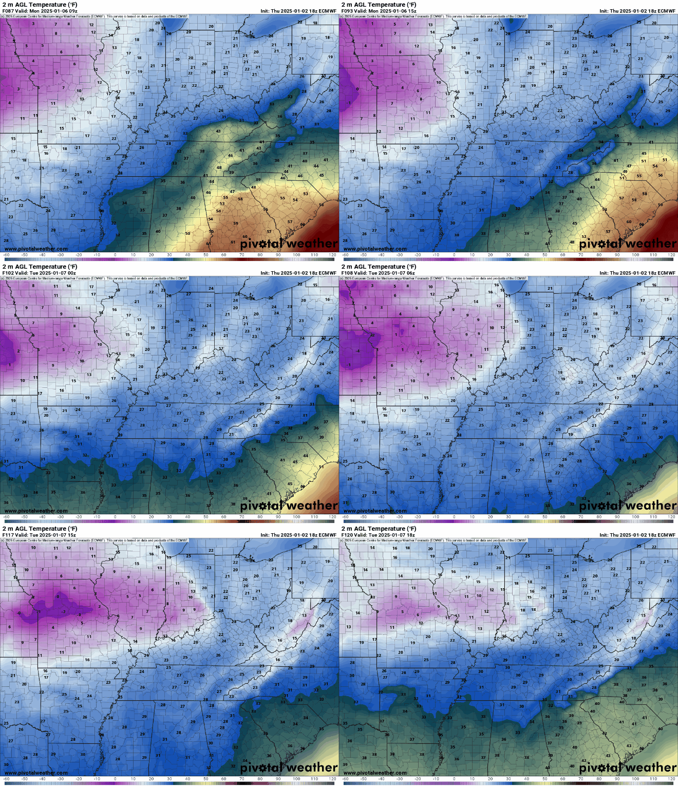
Highs will end up near 40º around midnight, but we’ll drop through the 30s and into the 20 as clouds continue throughout the region during the afternoon and evening hours. We’ll wind up bottoming out in the upper teens to lower 20s…with cloud cover.
Things looking much colder, but not much sunnier on Tuesday as highs only make it into the lower 30s. A reinforcing shot of arctic air settles in for the middle and end of the week. Tuesday night, we’ll struggle to keep it above 15º for a low, with highs Wednesday and beyond staying in the 20s.
That’s it for me for now! You can always keep up with the latest on all of our social media platforms. Have a tremendous day and a great weekend!

