

")

It’s been a less certain forecast than usual around WABBLES this past week as we’ve been dealing with rain chances from the north and the south. That pattern continues as we head into the weekend with the remnants of Helene moving into the Ohio Valley.
Helene Headed In: Friday and Friday Night
All eyes continue to be on the southern tier of the country as we watch Hurricane Helene continue to churn across the southeastern states. Helene made landfall last night in the Florida panhandle at Category 4 strength. Thanks to the peculiar pattern we find ourselves in, we can expect that as Helene loses tropical characteristics, it will be our gain in the rainfall department.
See, the cutoff low that’s been meandering through the region this week keeping us cloudy and stormy is going to interact with the remnant low of Helene, forcing said remnant low to move northwest toward WABBLES.

For us, this means a gusty, soggy day on Friday as the moisture from Helene works into the region, being forced by the remnant low. Showers and potentially some thunderstorms will be with us off and on through the day and into the nighttime hours. Highs look to be kept more than in check thanks to clouds and showers, with highs topping out in the lower to middle 70s.
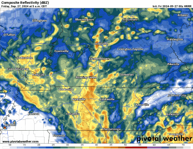
Outside of showers and storms, winds could gust upwards of 40-50 MPH at times as the center of circulation grows closer to the region. Not only could this cause trees to topple whose roots have been weakened by the rainfall, it could also lead to scattered power outages. At this point, severe weather chances seem low, but not entirely zero. That’s something we’ll continue to watch, especially overnight and into early Saturday. Lows overnight settle into the lower 60s.

Helene Hangs Out: Weekend Forecast
As Helene continues to run ashore and lose tropical characteristics, it will also continue to spin into a bit of a backed up setup in the region as the low from earlier in the week continues to sit tight. This could end up forcing continued showers through Saturday as the deep, tropical moisture continues to advect into the region.
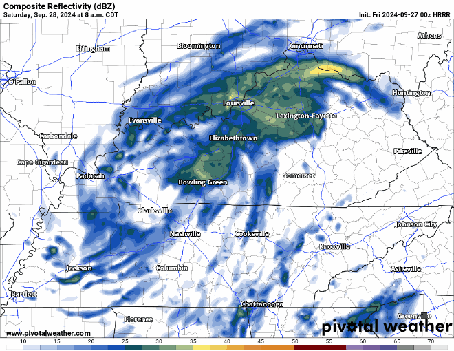
That will keep showers abundant, and highs down into the middle 70s, though we may overachieve at times if we can run into some sun breaks, but that could also lead to renewed thunderstorm chances. Showers continue overnight on Saturday as the lows remain in the vicinity.
More scattered showers continue Sunday as formerly-Helene and mister nuisance cut-off low continue to get to know one another in our soupy tropical airmass. We’ll keep highs in the mid 70s, again accounting for the possibility of a few sun breaks.

Before all is said and done this weekend, we may be looking at 3-5 inches of rain falling in WABBLES, with some locally higher amounts possible. Because we’ve been so dry recently, and this rainfall is falling over a long period of time, we’ll have plenty of time to soak in this rain. That also means that we’ll keep the flood risk low except for those areas that get under one of those repeated downpours.
Helene Heads Out: Early Next Week
The now-married former-Helene and her cutoff companion finally look to take their honeymoon outside the Ohio Valley as we head into early next week.

However, I do think we’ll continue to see influence from some northern branch systems that could keep some scattered showers in the forecast as we head through the middle of next week. The heat dome won’t be quite as pronounced either, though things do stay muggy.
Some showers look to hang out on Monday before becoming fewer and farther between as we head into Tuesday and Wednesday. Highs look to hang out in the middle 70s.
That’s it for me for now! You can always keep up with the latest on all of our social media platforms. Have a tremendous day and a great weekend!