")
Good Monday morning, WABBLES! Meteorological summer is in full swing as we head into a sunny, hazy, and almost uncomfortably dry week to start off the month of June.
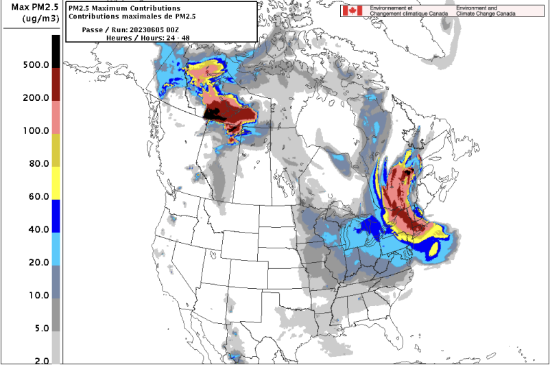
Smoke from the wildfires in Canada is expected to linger in our area over the next few days, which will keep any major precipitation squarely out of our region until further notice. But when will we see the return of clear skies and cooler temperatures? Let’s dive into it together in today’s blog!
Today’s Forecast
Today’s big story, as we mentioned earlier, is the pretty thick haze that will keep us dry and warm throughout the day today and into Tuesday. Temperatures are forecast to peak around the high-80s for a majority of the WABBLES region, while lows will swing into the low-60s after sundown.
A calm southward wind will cool us just slightly over the course of the morning, but will do little to remove some of that smoke from our atmosphere.
Sunny Through Midweek
Both the cloudless sky and the smoky haze will persist through around Wednesday at noon, when we get our first chance at seeing some precipitation for the week.
Temperatures will continue to swing around the high-80s until a small backdoor cold front pushes out of the northwest in the early afternoon on Wednesday, and the temperature gradient may give us enough forcing in the atmosphere to throw up some pop-up showers.
Overall, the coverage will be pretty spotty, so not all of WABBLES will see rain; but those who do should enjoy it, since it’s our last chance for precipitation this week!
Final Comments
And that’s what it’s looking like for the start of our week, WABBLES friends! Overall, once our potential showers move out on Wednesday, things will calm down quite a bit once again and the thick haze will be pushed out as well.
This week, if you have any outdoor plans, you’ll want to bring along that sunscreen and an umbrella— even though it may be smoky out, you can still get burned! Thanks for tuning into another WXornotBG blog, and please take care out there!